Identifier
KMP2014_T2
Type
en
shovel test
Title
KMP 2014 trench2
Description
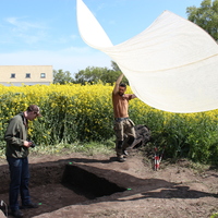
Trench 2 was located north of trench 1, just at the edge of the field, towards to Norrjevägen. It was a 1x1 meter shovel test dug to detect or deny the presence of preserved cultural layers.
The upper layer consisted of a stirred plow layer. It contained blunt flint, as well as recent materials. Flint consists of chip, rejection, and a core ax. The plow layer was about 40 centimeters deep and was followed by a thin sandy layer of a few centimeters. Under the sand layer, appeared moraine clay and thus sterile soil.
Investigation site
Kämpinge
Investigation dates
May 2014 – June 2014
Investigation technique
en
trowel
Creator
Date Created
June 22, 2022
Rights Holder
LU
License
en
CC-BY 4.0
Other Media
Linked resources
| Kämpinge 2014 |
| KMP2014 GIS data 01 |


| Plane | Position | Flip |
| Show planes | Show edges |
Measured length
0.0
0.0
Coordinates
[ 0 , 0 , 0 ]
[ 0 , 0 , 0 ]
Check All


