Identifier
KMP2014_T4
Type
en
shovel test
Title
KMP 2014 trench4
Description
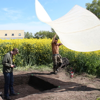
In Trench 4, the moraine never appeared and the trench ended up 1,5-2 m deep consisting of mixed layers. The southern profile in the trench revealed obvious ruptures in the stratigraphy (see Model) and at the bottom of the trench a stone packing appeared that either was considered to form a part of a natural beach ridge or possibly belong to a constructed stone packing (see figure)
Since all recovered artifacts from the Trench consisted of flint tools, flakes, and cores, the presence of a Late Mesolithic grave feature or a stone packing could not be ruled out. For this reason, it was decided that the 2014 field season was to be prolonged a couple of days, thus making it possible to extend the trench to the north.
Investigation site
Kämpinge
Investigation dates
May 2014 – June 2014
Investigation technique
en
trowel

Model measure unit
en
meter
Longitude shift
372000
Latitude shift
6142000
Spatial reference system (EPSG)
EPSG:3006
Creator
Date Created
June 22, 2022
Rights Holder
LU
License
en
CC-BY 4.0
Linked resources
| Kämpinge 2014 |
| KMP2014 Report by Anton Jernetz |
| KMP2014 Report by Linda Jungbeck |
| KMP2014 Report by Oscar Maddison |
| Test Kämpinge report |
| KMP2014 GIS data 01 |
| KMP2014 trench 4 01 (3D model) |
| KMP2014 trench 4 02 (3D model) |


")

