Identifier
KMP2014_T7
Type
en
shovel test
Title
KMP 2014 trench7
Description
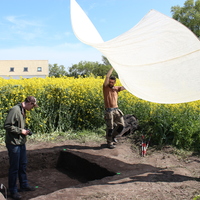
Trench 7, a 2x2 meter area, was opened in the nothern part of the site.
The trench was taken during the second day of the excavation, when samples indicated that any cultural layers were present on the site.
What differentiated this trench when compared to the others, except trench 4, was that the soil layer down to moraine showed to be thicker. However, during the excavation of the trench, recent findings were found all the way down to sterile soil, indicating that the entire surface consists of disturbed plow layers.
Investigation site
Kämpinge
Investigation dates
May 2014 – June 2022
Investigation technique
en
trowel

Model measure unit
en
meter
Longitude shift
372000
Latitude shift
6142000
Spatial reference system (EPSG)
EPSG:3006
Creator
Date Created
June 27, 2022
Rights Holder
LU
License
en
CC-BY 4.0
Linked resources
| Kämpinge 2014 |
| KMP2014 Report by Sofia_Briving |
| KMP2014 GIS data 01 |
| KMP2014 trench 7 01 (3D model) |
| KMP2014 trench 7 02 (3D model) |


")
